Ultimo
aggiornamento: 15 luglio 2004, ore 16:30
Visitatore n. 718
Il terremoto MD=5.1 di Kobarid (SLO) del 12 luglio 2004
La rete
sismometrica del Friuli-Venezia Giulia del Dipartimento Centro Ricerche
Sismologiche (CRS) dell'Istituto Nazionale di Oceanografia e di Geofisica
Sperimentale - OGS ha registrato in data 12/07/2004 alle ore 13:04 GMT
(15:04 ora locale) un terremoto la cui localizzazione preliminare è:
Latitudine : 46°18.9' N
Longitudine: 13°42.2' N
Profondità: 7.9 km
Località: Kobarid (Slovenia)
Magnitudo (da durata, MD): 5.1
Meccanismo focale: trascorrente (strike=135, dip=83, rake=173)
Le due mappe mostrano la localizzazione ed il
meccanismo focale.
Il terremoto è stato avvertito distintamente in gran parte del Nord-Est d'Italia.
Dai sismogrammi registrati si riconosce che l'evento del 12 luglio scorso è complesso e potrebbe essere composto da una doppia rottura. Il meccanismo focale iniziale è identico a quello dell'evento di MD=5.6 del 12/04/1998. L'effetto combinato delle due rotture può spiegare la percezione dello scuotimento avvertito dalla popolazione, che sembra essere in taluni casi maggiore rispetto all'evento del 1998.
La sequenza sismica conseguente all'evento principale sopra riportato è composta finora da una serie di repliche di piccole entità (magnitudo, MD, compresa tra 1.4 e 3.4) localizzate nella medesima zona dell'evento principale.
 |
Lista degli eventi in tempo reale |
Vedi i sismogrammi dell'evento principale registrati dalla rete sismometrica del Friuli Venezia Giulia (RSFVG) dell'OGS-CRS.
Vedi i sismogrammi dell'evento principale e degli aftershocks registrati dalle stazioni broadband di Trieste e di Villanova, gestite dal DST dell'Università di Trieste e dall'OGS-CRS.
INTERVENTO CON LA RETE DI ACQUISIZIONE MOBILE
L' OGS-CRS e l'INGV, in collaborazione con il servizio sismologico dell'agenzia per l'ambiente della Slovenia (ARSO), hanno dislocato nell'area epicentrale dell'evento una rete di 10 stazioni mobili (vedi mappa), in funzione dal 13/07/04.
ALCUNI CENNI SULLA SISMICITA' DELL'AREA
Per l'area colpita dall'evento, i cataloghi storici (NT4.1; Camassi and
Stucchi, 1997) riportano i seguenti eventi principali:
· 24/04/1279,
Cividale IMCS = VIII ;
· 11/06/1301, Cividale IMCS =VI ;
· 06/09/1403, Cividale IMCS =VII-VIII ;
· 26/03/1511, Gemona IMCS =VIII- IX (noto anche come
terremoto di Idria);
Fino al 1998 l'attività sismica registrata -
ricordiamo che la rete sismometrica del Friuli Venezia Giulia è in funzione
dal 1977 - è di basso livello energetico (MDmax=3.1-3.2) e piuttosto
sparpagliata nell'area.
A partire dal 1998, l'area manifesta invece una vivace attività sismica, ma
sempre caratterizzata da livelli di magnitudo non elevati.
L'evento più rilevante, registrato dalla rete sismometrica, è il
terremoto MD=5.6 del 12 aprile 1998 avvenuto vicino a Bovec.
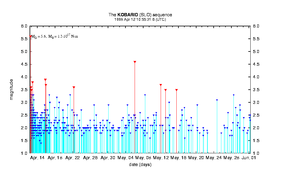
La sequenza delle repliche dell'evento del 12 aprile 1998 ha compreso circa
800 eventi, avvenuti per tutto il 1998. La replica più forte è stata un
terremoto di magnitudo MD=4.6.
Successivamente l'attività sismica dell'area può essere così riassunta:
· 1999: ripresa dell'attività sismica con 6-7 eventi di MD da 3 a 3.8;
· 2000 e 2001: minore attività sismica (MDmax=2.9);
· 2002: ripresa dell'attività sismica tra luglio e settembre 2002 con MDmax=3.8
(in località Kobarid (SLO));
· 2003: attività sismica più bassa e meno frequente (MDmax=2.7).
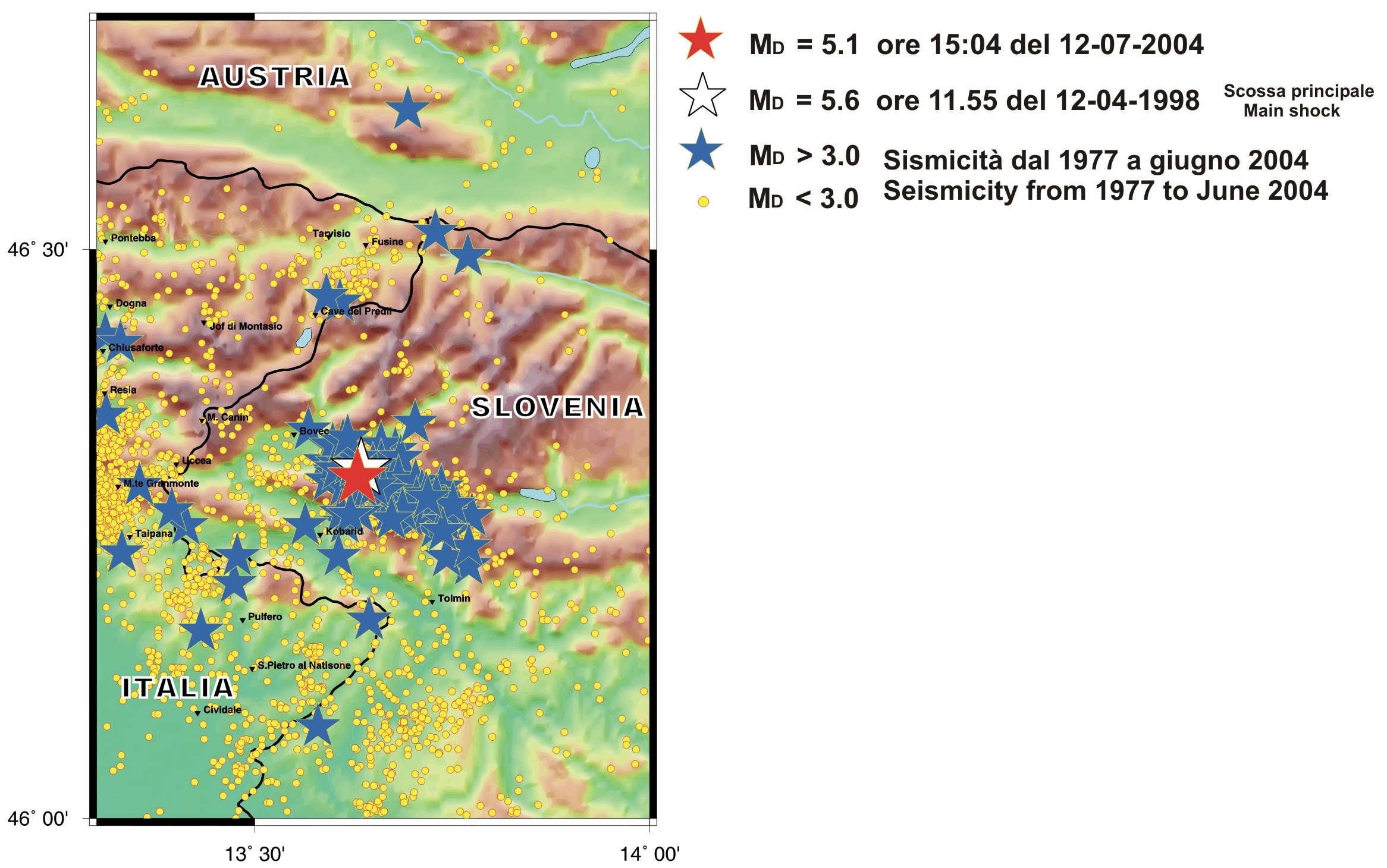
L'evento
appena avvenuto è localizzazto molto vicino al precedente terremoto del
1998. La figura descrive l'attività sismica nella zona
dal 1977 ad oggi.
Altre informazioni sui terremoti e la sismologia in generale possono essere
trovati in
questo sito.
LINKS su altri siti che descrivono questo evento:
The July 12 2004 MD=5.1 Kobarid (SLO) earthquake
Last update: July 15, 2004 at 16:30 local time
The
seismometric Friuli-Venezia Giulia network of the Seismological Research
Centre (CRS), a Department of the National Institute of Oceanography and
Geophysics (OGS), has recorded an earthquake on June 12, 2004 at 13:04 GMT
(15:04 local time). Location and magnitude of this event are:
Latitude : 46°18.9' N
Longitude: 13°42.2' N
Depth: 7.9 km
Location: Kobarid (Slovenia)
Magnitude (from duration, MD): 5.1
Meccanismo focale: strike-slip (strike=135, dip=83, rake=173)
The maps show localizations and
focal mechanism, respectively.
This earthquake has been felt clearly in a broad area of North-East Italy. A quick analysis of the recorded seismograms suggests that the July 12 event is a complex two-phase rupture. The starting focal mechanism is very similar to that of the event MD=5.6 of 04/12/1998. The combined effect of the two ruptures might explain the ground shaking that has been reported higher than that of 1998 in some cases.
The main
event has been followed by a seismic sequence of
about 70 aftershocks (with MD between 1.4 and 3.3), which are localized
within the same area.
 |
See seismograms of the main event recorded by the OGS-CRS Friuli Venezia Giulia seismometric network.
See seismograms of the main event and of the aftershocks recorded by the Trieste and Villanova broadband stations, managed by DST (University of Trieste) and by OGS-CRS.
TEMPORARY SEISMIC NETWORK
Beginning from the 13 July a temporary network of 10 stations (see map) has been activated by OGS-CRS and INGV, in collaboration with the seismological service of the enviromental agency of the Republic of Slovenia(ARSO), in order to improve the monitoring of the seismic sequence.
HINTS ON HISTORICAL SEISMICITY
The historical catalogues (NT4.1; Camassi and Stucchi, 1997) reports the
following main events in the area:
· 24/04/1279, Cividale IMCS = VIII ;
· 11/06/1301, Cividale IMCS =VI ;
· 06/09/1403, Cividale IMCS =VII-VIII ;
· 26/03/1511, Gemona IMCS =VIII- IX (known also as the
Idria earthquake);
Till the 1998 the registered seismic activity - the seismic network in
Friuli is active from 1977 - is characterized by a low energetic level (MDmax=3.1-3.2)
and it is quite scattered in the area.
From 1998, the area presents an high seismic activity, but always
characterized by low levels of magnitudo.
The most relevant event, recorded by the seismic network, is
the
12th April 1998 earthquake (MD=5.6) , located near Bovec.
The sequence of aftershocks of the 12th April 1998 event consisted in about
800 events, during all the 1998. The higher intensity aftershock was a MD=4.6
magnitudo earthquake.
Afterwards, the seismic activity in the area can be summarized in the
following way:
· 1999:
resumption of the seismic activity with 6-7 events characterized by 3.0<MD<3.8;
· 2000 e 2001: lower seismic activity (MDmax=2.9);
· 2002: resumption of the seismic activity between July and September 2002
with MDmax=3.8 (Kobarid (SLO));
· 2003: lower and less frequent seismic activity (MDmax=2.7).
The epicenter of the most recent earthquake is localized very close to the
12th April 1998 MD=5.6 event epicentral area. The figure
describes the seismic activity in the area from 1977 to now.
LINKS:
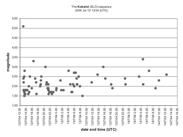
Le magnitudo della sequenza sismica aggiornata alle ore 15.00 del 15 Luglio
The magnitudes of the seismic sequence updated to July 15, 3.00PM local time.
|
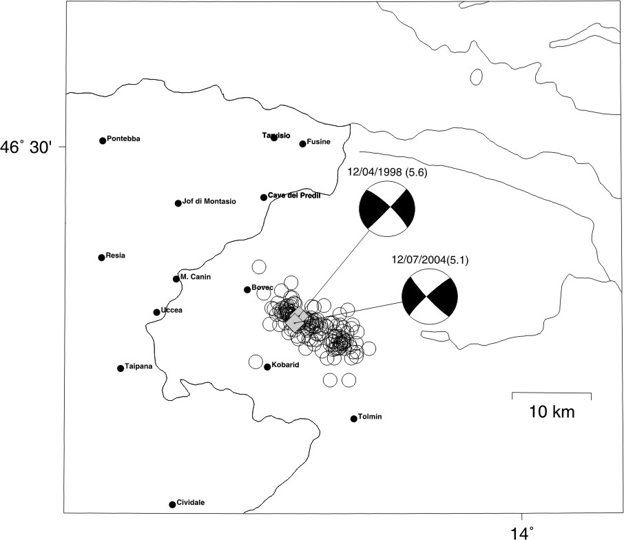
Meccanismo focale dell'evento di MD 5.6 del 12 aprile
1998 (Bressan et al., 2003) e dell'evento di MD 5.1 del 12 luglio
2004. I cerchi rappresentano le repliche con MD = 2.5 dell'evento
del 1998.
Il meccanismo focale del 1998 è stato elaborato con 71 polarità. Il meccanismo focale del 12 luglio 2004 è stato elaborato con 60 polarità. Parte dei dati relativi alle polarità è stata cortesemente fornita dall'Istituto Nazionale di Geofisica e Vulcanologia (Roma), dalla rete sismometrica della Provincia Autonoma di Trento e dall'Agenzia per l'Ambiente della Repubblica Slovena (ARSO)- Servizio Sismologico (Ljubljana). |
| The
focal mechanism of the 12 april 1998 event (MD=5.6) (Bressan et al.,
2003) in comparison with the 12 July 2004 (MD=5.1). The circles are
aftershocks (MD=2.5) of the 1998 event. The focal mechanism of the 1998 event has been obtained using 71 polarities. The focal mechanism of the 2004 event has been obtained using 60 polarities. Part of the data used was provided by INGV (Rome), Provincia Autonoma di Trento and Environmental Agency of the Republic of Slovenia (ARSO)-Seismological Service (Ljubljana) . |
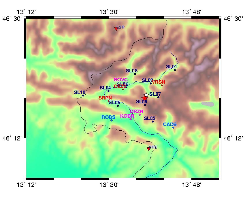
Mappa
delle stazioni in area epicentrale
In blu: stazione della rete mobile INGV-OGS
In rosso: rete mobile slovena
In viola e azzurro: stazioni rete fissa del servizio sismologico sloveno.
I triangoli rossi: stazioni rete fissa OGS
Location map of the sismological network in the epicentral area.
Blu circles: temporary INGV-OGS network
Red diamonds: mobile Slovenia Network
Light blue and violet diamonds: Slovenia seismological service permanent
network.
Red triangles: OGS permanent network
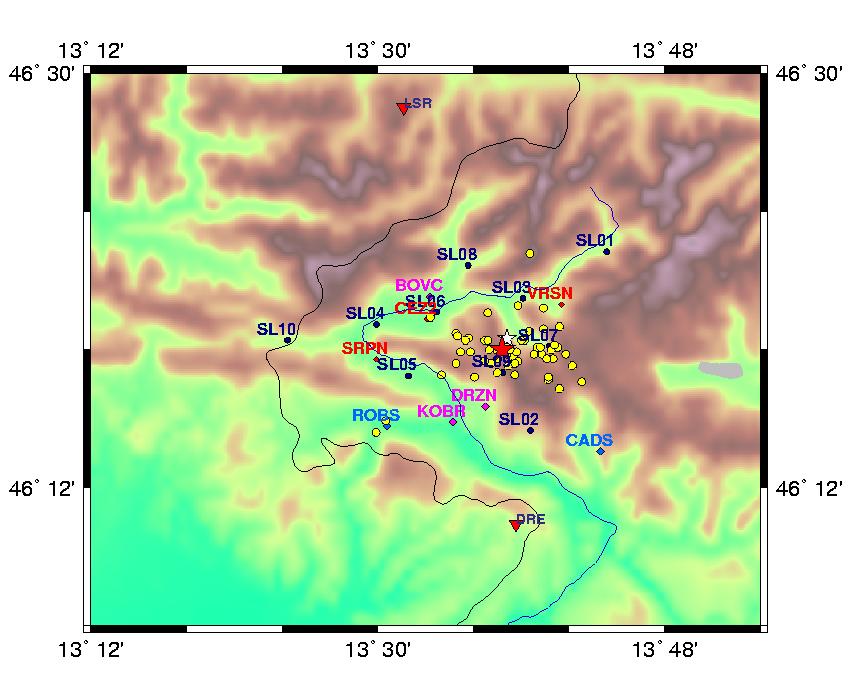
Mappa
delle localizzazioni preliminari della sequenza di Kobarid del 12.07.2004:
eventi con magnituto maggiore di 2.0.
Preliminary location map of the Kobarid seismic sequence (12.07.2004):
events with magnitude greater than 2.0.
